Specific Services:
- Site evaluation
- Restoration design
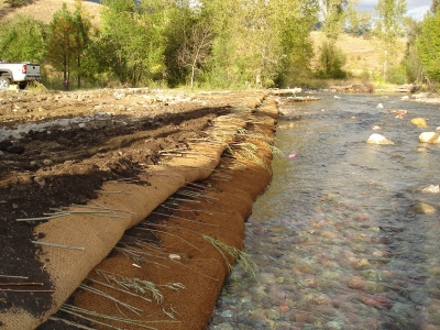
- Streambank bioengineering and erosion control
- Habitat creation and enhancement
- Revegetation design
Example Projects:
- Clark Fork River Remediation
- Upper Blackfoot Mining Complex
- Milltown Dam Restoration
- Jocko River Restoration and Master Plan
- Wimpey Creek
- Therriault Creek Stream and Wetland Restoration
- Kootenai River Habitat Restoration Program
Specific Services:
- Wetland evaluation and survey
- Wetland delineation
- Design of wetlands for improving water quality
Example Projects:
- Shiloh Conservation Area
- Coleman Coulee/Moiese Wetlands
- Baker Lake
- Wastewater Lagoon Best Management Practices Literature Review
Geospatial Services:
- Drone Mapping
- High resolution aerial imagery, digital terrain models, and high-definition video captured with our Phantom 4 Pro drone.
- Data Collection
- Resource-grade spatial data collection, processing and mapping to support natural resource and infrastructure field assessments.
- Custom Maps
- Custom maps, posters, presentations and 3D prints to help visualize, share and communicate your data.
- Planning & Design
- Assessment of project site potential, construction or restoration feasibility, project quantities and costs, and more.
- Elevation Data Processing & Analysis
- Analysis of existing LiDAR, bathymetric and survey data to create high-resolution elevation datasets.
- GIS Support & Project Management
- Expand your GIS capabilities and capacity with custom workflow development, data aggregation and organization, and remote project support.
For more information on Geum’s geospatial services, and to see some of the ways we use GIS within our existing projects, please visit our accompanying website GeumGeospatial.com
Specific Services:
- Web-based ecological data management
- Wetland mitigation monitoring
- Effectiveness monitoring program design
- Adaptive Management program design
Example Projects:
- Little Blackfoot Riparian Assessments
- Plum Creek Grazing Study
- Bitterroot Subbasin Plan
- Bitterroot Wetland Mapping
Specific Services:
- Permit acquisition
- NEPA compliance
- Wetland delineation
- Endangered Species Act compliance
- Riparian management plans
- Mitigation plans
Example Projects:
- Baker Lake
- Crooked River
- Dowton Aquatic Habitat Assessment
- Ninemile Creek Restoration
Specific Services:
- Watershed and subbasin planning
- Master Plan development
- Baseline ecological inventories
- Botanical surveys
- Stream habitat surveys
- Riparian and wetland assessments
- Grassland restoration
- Mine site revegetation
- Erosion control
- Grazing management
- Invasive species management plans
- Native seed coordination and mix development
Example Projects:
- Bitterroot Subbasin Plan
- Clark Fork River Remediation
- Upper Blackfoot Mining Complex
- Milltown Dam Restoration
- Jocko River Restoration and Master Plan
- Kootenai River Habitat Restoration Program
- Crooked River
- Little Blackfoot
 |